Why Land Surveys are Crucial to your Building Project
Land surveying is a necessary and important step of the building process. The first survey should be completed prior to plans being drawn to confirm corners of the lot, elevation changes, trees and existing structures. An additional survey should be completed before construction begins to locate the corners of the house, and to make sure setbacks and orientation are correct. Although surveys are an added expense to a construction project, it is money well spent to prevent errors from occurring during down the road.
Common issues from not having a survey prepared
- Delays City or County plan reviews, which can disrupt the entire construction time-line
- Possibility of the structure being built too high or low
- Unnecessary removal of trees
Cost Savings
- The entire building team has a good picture of the project site, eliminating many potential problems
- Less time guessing and more time performing work
- Better planning up front always saves money in the end
- A survey is excellent documentation to have in case of issues down the road
- Spend less money by eliminating/decreasing the need for architectural and builder change orders
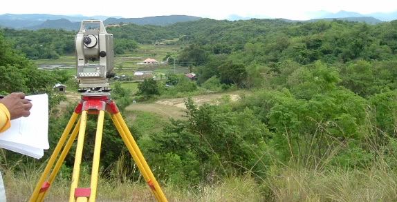
Methods of surveys
– Topographical surveys are the ideal way to distinct natural & artificial developments on a site. Architects & engineers use these maps to aid in the designing or development of a site. Topographic maps help in finding fences, elevations, land contours, trees streams, buildings & other improvements on a building site.
– Boundary surveys establish boundaries of a parcel using its legal description, which typically involves the setting or restoration of monuments or markers at the corners or along the lines of the parcel, often in the form of iron rods, pipes, or concrete monuments in the ground, or nails set in concrete or asphalt. The surveyor takes into account previously recorded markers along with the new improvements on the land while preparing the true boundary lines of a property.
– ALTA/ACSM surveys: a surveying standard jointly proposed by the American Land Title Association and the American Congress on Surveying and Mapping that incorporates elements of the boundary survey, mortgage survey, and topographic survey.
Categories: Site Work